The vast poetry of empty streets and colorful houses leaves a lot of space for imagination and dreaming following irrevocably very old ambitions. At noon the sun now moves slowly around the very next corner where the shadows shrink to minimalistic images of black, white, blue and red. All is slowing down irresistible, and time stands still for a while. A real moment of peace in a world full of archaic, violent and stupid conflicts all over our nice blue planet!
Wishing you a very nice season and a happy new year 2024 🎃💥🥳
It doesn’t matter if the road is long, as long as there is a well at the end. (Tuareg proverb)
“A Street in Gadames” by Giorgio Oprandi, 1929.
Water is our cool elixir, which unfortunately is not available everywhere in the world. But as climate change progresses, desert and semi-arid areas around the world will expand even further, while countries like Spain or Italy are already experiencing water shortages in summer.
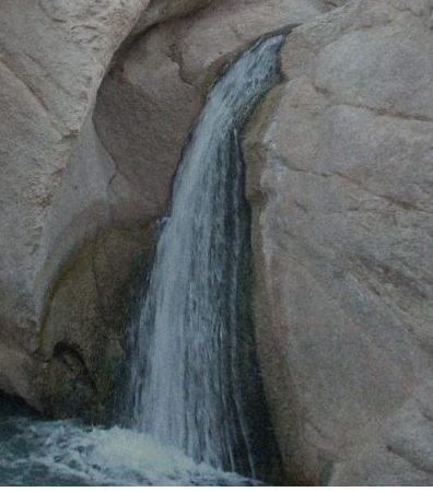
Here the water still gushes abundantly in the mountain oasis of Tamerza
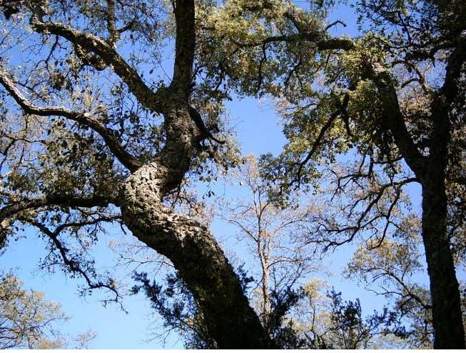
From the main road between Tabarka and Bizerte we had to drive 15 km over deserted sandy roads to reach Cape Negro, a forgotten and abandoned place on the Mediterranean coast with typical vegetation, a rather cool wind from the sea and also a long sandy beach without other people, there in the area you can also still find the typical cork oak forests.
Cork oak in a forest near Tabarka not far from the Algerian border
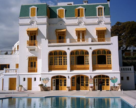
“Hotel Les Mimosas” in Tabarka
Doesn’t this hotel really look very French? The beautiful place is situated on a small hill and offers a beautiful view of Tabarka and the sea.
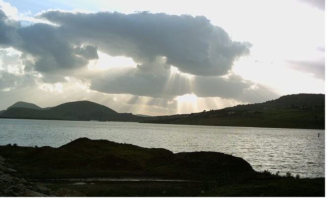
Sidi-el-Barrak water reservoir near Nefza
This reservoir in the very green north of Tunisia is also a completely untouristy place, but at this moment in the late afternoon, the mood and the interplay of light, clouds and water revealed something different.
The Atlas massif divides Tunisia, and the great Sahara begins at its southern edge.
Consider that 2,000 years ago, Tunisia was still the granary of the Roman Empire. Since then, the warm period after the last ice age and normal climate change have transformed formerly very fertile areas into vast wastelands and endless desert zones. And the Sahara has not stopped its unchecked expansion to this day.
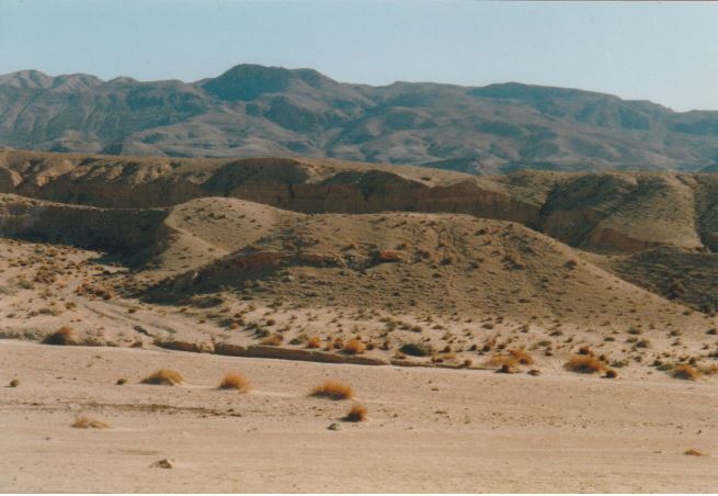
Cracked desert between Tozeur and Tamerza, Sahara
This photo remains one of my favourite travel memories from Tunisia and shows a single hardy bush in an area of cracked and parched ground, probably due to very rare and heavy rains some time ago.
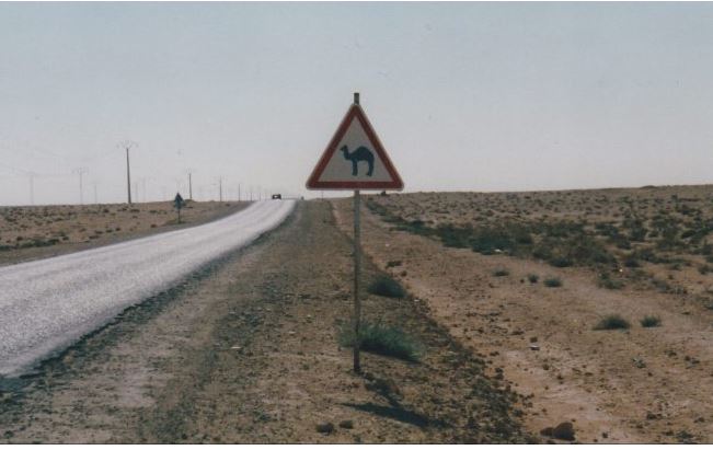
But where are the legendary dromedaries? Not a single one here.
The photo was taken on the main road coming from the north and Tunis, which is now really deep in the south somewhere between Metlaoui and Tozeur.
The cave dwellings of Matmata, also known as the home of Luke Skywalker in Star Wars.
Halfway between Tozeur and the Djerba Peninsula lies the cave village of Matmata, where people have lived for millennia and which was made wellknown by the famous cult film series Star Wars. The landscape is quite barren with only a few dwellings on the surface, but the magic of Matmata goes deeper and reveals itself to guests when they descend into the unique underground cave dwellings, which offered their inhabitants good protection from extreme cold at night and the burning sun during the day.
Arab Scene in Tunisia, Ernesto Quarti Marchio, 1933
Small paradise and tiny water well near the Douz oasis.
The Sahara desert used to be a vast sea where nomads made their endless sailing trips on dromedaries (not camels), some still do. Nevertheless, I really appreciate the desert (as well as high mountains) as a very purist place with a clear, unlimited view to the distant horizon that can clear your mind and broaden your horizons, a really exciting feeling besides all the known dangers and risks.
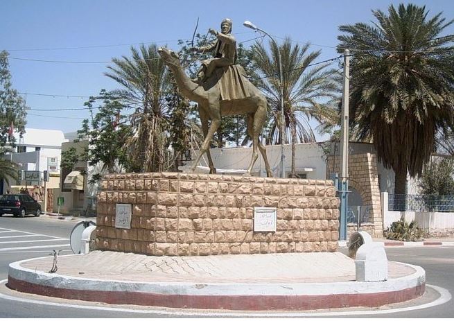
Nomadic monument at a road junction in Douz.
The oasis of Douz is a real gateway to the Sahara and today has about 30,000 inhabitants. The desert dunes near Douz are famous because they consist of an incredibly soft and almost white sand. The area is traditionally inhabited by the semi-nomadic Mrazig tribe, an Arab Bedouin tribe that left the Arabian Peninsula in the 8th century and settled in Tunisia in the 13th century. Today, many make their living from date harvesting, and probably the best dates in Tunisia come from Douz, called Deglet en Nour. The “gold of the oasis” is therefore more than just any fruit for the inhabitants of Douz.
Death zone of the huge salt lake Chott-el-Jerid after sunset.
Today, the huge salt lake Chott-el-Jerid can be crossed safely on a solid dam with a road that also connects the oasis areas of Nefzaoua and Tozeur. In the past, such a journey was a dangerous adventure.
Not suitable for drinking – only the salty water of Chott-El-Jerid
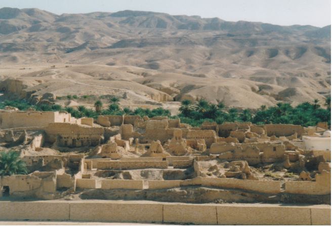
Ruins of the ancient city and mountain oasis of Tamerza
Now this trip here has really become more of a collage of texts, impressions and diverse pictures collected from various places in the vast and beautiful Tunisia.
Breakfast with fresh flower blossoms in the oasis of Tozeur
“A sense of humor is the pole that adds balance to our steps as we walk the tightrope of life.” (Arabic proverb)
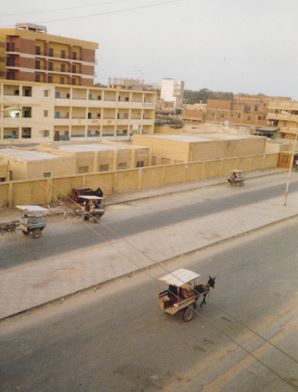
A very mythological place in Egypt is the Oasis of Siwa which was not so easy to reach in 1985. From Alexandria I took a regional bus to the small town of Marsa Matruh being situated at the coast not far away from the Lybian border in the very West. On the photo above and hereunder you see a typical street-scene with a donkey cart and of course the old bazaar there. But I had to stay in this town in order to get a special permission from the local authorities for visiting the Oasis of Siwa (being also a military’s exclusion zone), this alone took me around 2 days. It is a rural area, just normal life and more unspectacular except one very strange and bizarre exhibition on the outskirts of Marsa Matruh.
I am quite sure that this must be the only place in the world where a museum honours the Nazi general Erwin Rommel with the still existing Rommel’s Cave Museum (see photo hereunder). Just before Rommel’s Beach is the cave system where Rommel planned the axis forces’s military operation during WW II. The caves are now home to a small museum that displays some of his personnel effects and the maps he drew up here presenting him as a hero. The Egyptians did not like very much to be part of the British Empire while their great hope to become independent after WW I was not respected by the colonial powers at Versailles. So the Egyptians appreciated when the German Wehrmacht invaded Northern-Egypt in the naive hope for a principal change of their fate after being first occupied by the Osmans for long time and then later by the British. And they especially admired the combat strategy of Rommel in North-Africa standing in the tradition of the Bedouins. Although Rommel committed suicide in October 1944 due to imminent punishment after an officer’s rebellion against Hitler, this place made me dazzled and speechless however as the complete museum did simply ignore the devastation of great parts of Europe, the holocaust and the millions of other deaths as a result of Nazi-German cruelties (27 millions dead people alone in the former Soviet-Union).
After this unexpected historical abyss, I was happy to leaveMarsa Matruh for my visit of the Oasis of Siwa which was also reachable by a daily bus through the Lybian desert. On the way to Siwa a lot of military vehicles could be seen because the Egyptian army held some military compounds in the oasis. Those days the crazy colonel Muammar Ghaddafi was the revolutionary head of the Lybian state, and the Egyptians simply did not trust him. Therefore, the whole territory stood under special military’s control. The street to Siwa was not in the very best condition but this is nothing unusual in a desert with great differences in temperature from day to night. It took around 3.5 hours with the bus from Marsa Matruh to Siwa, so I did arrive in the early afternoon when it was really hot, not surprisingly hardly anybody on the streets of Siwa upon my arrival.Not far away from the bus station I found a rather simple hotel in the oasis, I think it was the only one, but it offered good protection against the burning sun and strong heat, what was the most important here. The breakfast and meals were of more modest character, and in the oasis in general a mediaval feeling struck my mind as if being hardly put back in time.
The oasic region of Siwa is the only place in Egypt with a Berber population (ca. 23,000), culture and language called Siwi. It is lying in the Qattaradepression around 18 m under sea-level, therefore water finds very easily its way to the surface being the basis for life in a desert. The agriculture of Siwa comprises mainly the massive production of dates and olives but as well also diverse vegetables for daily life and local consumption. So vast areas are simply covered by the evergreen date palm-trees.
The history of the oasis can be followed back in history till the 18th Pharaonic dystany (1,500 B.C.). At that time the climate was much better and North-Africa much greener, hence the Egyptians erected here an important Temple of Amun – a location with a very well-known oracle. Even Alexander the Great made use of this powerful oracle of Siwa and upon his visit was welcomed as the true sun of Zeus. The next two photos show the debris and ruins of the Temple of Amun in Siwa.
The course of time created surreal landscapes here being once the meeting rooms of famous and powerful people. But I had more places to discover in Egypt, so my time in Siwa was limited because now the endless Nile valley was calling me.
The legendary Gogomobil was once manufactured in the Lower Bavarian town of Dingolfing, but today a huge BMW plant stands here instead, and these new cars of today are far less spectacular, instead pure show-off paraphernalia with plenty of horsepower to satisfy archaic desires and equally a regular imposition with aggressive driving on German and other roads. Below are some advertising posters and technical insights picked up in the Dingolfing museum, artefacts from another and also still purely analogue time.
Preparing for the Day of the Dead – public skeleton sculpture
In late October of 1997 I had the pleasure to stay for a week in Mexico D.F and Merida / Yucatan. What I did not know this is the time when Mexicans prepare themselves for the Day of the Dead (Día de Muertos). Especially in Merida I was dazzled to see shops full of plastic skeletons of any kind, souvenirs, decoration and weird disguise all related to the topic of death. This reminded me all of European carnival however with a different purpose and a more strange direction.
Central place with nice green shadows and town hall at Merida
Sweet death – delicious sugar coffins in a shop
Prior to Spanish colonization in the 16th century, the celebration of death took place at the beginning of summer. And the origins of the modern Mexican holiday can be traced back to indigenous observances dating back hundreds of years and to an Aztec festival. Gradually, it was associated with October 31, November 1, and November 2 to coincide with the Western Christianity, nowadays legal holidays to remember friends and family members who have died.
View on Chichen Itza Castle with really steep steps
View from Chichen Itza Castle on the jungle of Yucatan
Today the view from the old temples and buildings at Chichen Itza just reveals a total wilderness and endless rainforest which more than thousand years ago meant the homeland for the Maya, a loose alliance of city-states in southern Mexico, Guatemala and Belize. You do not see anymore the cities, roads, reservoirs, channels or terraced fields being swallowed again by a thick jungle.
Cryptical message and petroglyphs from the past
Around the year 900 the Maya quickly and more mysteriously left the country and vanished most probably due to a climate change, little food and too much fighting. Estimations say that the population dropped around 90 % during this time. At a few locations, such as Chichen Itza, the Maya still lived furtheron, though they would never gain their former grandness.
In den 1970er Jahren entwickelte sich die Graffiti-Szene, inspiriert von der aufkeimenden Hip-Hop-Bewegung, schließlich im New Yorker Untergrund. Innerhalb weniger Monate wurde sie zu einer gigantischen Welle, die auch auf Europa überschwappte. Die Punks und der Hip-Hop brachten die Streetart in ihre Hochburgen London und Amsterdam, von wo aus sie nach West-Berlin gelangten.
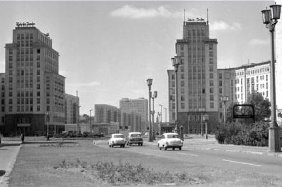
Blick auf neu errichtete Häuser in der Stalinallee, Berlin-Friedrichshain, 1963
Wandfries von Walter Womacka Haus des Lehrers, Berlin-Mitte, 1965
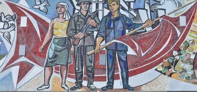
Auch in Ost-Berlin gab es Formen der Straßenkunst, allerdings waren die Künstler in ihrer Freiheit stark eingeschränkt und mussten sich streng an den verordneten sozialistischen Realismus halten, wie hier auf dem Wandfries von Walter Womacka aus den 1960er Jahren zu sehen. Auch in Ost-Berlin wurden politische Parolen an Häuser und Wände gemalt, die aber meist sofort von der Staatssicherheit entfernt wurden. In West-Berlin präsentiert sich die Berliner Mauer zunächst nur als riesige Leinwand, auf die ab den 1970er Jahren politische Parolen, Wandbilder und später Graffiti gemalt und gesprüht werden.
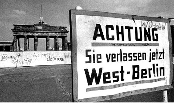
Die teilende und tödliche Berliner-Mauer, 1961-1989
Wandfries von Walter Womacka Haus des Lehrers, Berlin-Mitte, 1965
In ihren Anfängen fand die Streetart viele Befürworter. Der Zweite Weltkrieg hatte in Berlin viele Spuren in Form von Brandmauern und Bombenblindgängern hinterlassen, die durch die Wandmalereien verdeckt werden konnten. Die Politik förderte die Streetart-Projekte in West-Berlin mit Gestaltungsprogrammen und Wettbewerben wie Kunst am Bau. Zahlreiche Künstler brachten unterschiedliche Stile und Techniken mit, das Ziel war ein aktiver Eingriff in das Stadtbild.
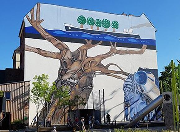
Ben Wagin, “Weltbaum” Berlin-Tiergarten, 1977/2018
Alles begann mit einem stöhnenden Baum, der von heftigen Autoabgasen umgeben war. Das Umweltwerk “Weltbaum” von Ben Wagin war das erste große Wandbild, das 1977 im Westteil Berlins entstand. Aufgrund von Bauarbeiten ist es nicht mehr an seinem ursprünglichen Platz zu sehen. Deshalb wurde es im Mai 2018 an einem geeigneten Gebäude in der Lehrter Str. neu gemalt und rekonstruiert.
Gert Neuhaus, “Zipper”
Berlin-Charlottenburg, 1979
Marilyn Green, Rainer Warzecha und Christoph Böhm “Modell Deutschland”, Berlin-Kreuzberg, 1981
Politische Parolen, die auf Hauswände gemalt oder gesprüht werden, sind seit jeher Teil politischer Bewegungen, nicht erst seit der westdeutschen Hausbesetzerbewegung der 1970er und 1980er Jahre, die sich dieses Ausdrucksmittels intensiv bedient. Besonders stark und aktiv war die Hausbesetzerbewegung in West-Berlin, wo viele Häuser ungenutzt, leer oder in sehr schlechtem Zustand waren.
Hausruine am Winterfeldplatz
Berlin-Schöneberg, 1981
Wandgemälde auf einem besetzten Haus KuKuck, Berlin-Kreuzberg, 1982
Die Werke, die in den 1970er Jahren in West-Berlin und später in der Hausbesetzerbewegung der 1980er Jahre entstanden, hatten oft eine politische Botschaft – wie der “Weltbaum” von Ben Wagin oder das inzwischen verschwundene Wandbild “Modell Deutschland” von Marilyn Green, Rainer Warzecha und Christoph Böhm. Auch die Illusionsmalerei war sehr beliebt. Ein Beispiel ist der noch heute existierende Giebel “Zipper” des Künstlers Gert Neuhaus.
Sigurd Wendland, “Potsdamer Str. 1945”, 2. Weltkriegsbunker, Berlin-Schöneberg, 1983
Harald Juch, “Chernobyl Disaster”
Berlin-Schöneberg, 1986
Blick auf den Kurfürstendamm
Berlin-Charlottenburg, 1987
Gert Neuhaus, “Phönix” Berlin-Charlottenburg, 1989
Illegale Untergrundkunst existierte im gegenseitigen Einvernehmen neben Auftragsarbeiten, die meist von Wohnungsbaugesellschaften vergeben wurden. Manchmal überschnitten sich die Arbeiten auch, oft verschwanden sie wieder. Mit den großen politischen Umbrüchen ab Ende 1989 hat sich in Berlin auch in Bezug auf die urbane Kunst viel verändert, aber das ist bis heute so geblieben!
Alt ehrwürdiges nun aber doch leerstehendes und vergessenes Bürgerhaus in der sonst ja überperfekten Fussgängerzone von Dingolfing
Ja mei, waas is dänn hiar passiert? Eine Ruine inmitten einer bayerischen Konsumhölle, da hat der Bürgermeister aber seine Hausaufgaben wohl nicht gemacht bzw. erledigt!
Grabschmuck auf dem Friedhof von Reisbach
Rostskulptur von Fritz Koenig, Koenig-Museum, Landshut
Nun danach ein bischen weitergegangen und dann noch über Rost aller Arten gestolpert. Und das nennt sich dann selber gar “Premium-Region”, ja schön fabuliert und phantasiert, letztlich ist Allem immer der Niedergang unwiderruflich sicher.
Fundstück am Wegesrand irgendwo in Niederbayern
Eine andere Hausruine in einer Seitengasse von Dingolfing gut versteckt; und die steht nun schon seit über 50 Jahren so leer herum
Die Zeit steht schon still um die Ecke, eine Sekunde des Innehaltens wird zur Stunde der Wahrheit ganz selbstvergessen und romantisch. Wir brauchen mehr solche Orte der Meditation, dann geht es auch voran mit poetischen Ausblicken auf eine schier unglaubliche Zukunft, in der wir uns ganz und gar verlieren können und selbst zum phantastischen Fundstück am Wegesrand werden!
Die Natur erobert nach und nach diese Vergessenheit – eine doch willkommene und perfekte Symbiose von Raum und Zeit
++++++++++++++++++++++
Phillip Boa and The Voodoo Club, Bay Rum, 2023
*****************
For any feedback please use the contact formula on my website!
Warum wandert eine weltliche Person wie ich auf den mythologischen BergSinai (arabisch: Gebel Musa, 2.285 m) im Oktober 1985? Der Moses-Berg liegt im Herzen einer bergigen Wüste auf der gleichnamigen Halbinsel, nun, ich muß wirklich mein Gehirn und mein Gedächtnis anstrengen, da ich während dieser selbstorganisierten 4-wöchigen Reise durch ganz Ägypten vor langer Zeit kein Tagebuch geschrieben hatte.Zumindest existieren noch ein paar analoge Fotos, und die müssen daher als unterstützende Schreibanleitung dienen.
In den 80er Jahren des letzten Jahrhunderts war das Reisen viel aufregender und unvorhersehbarer als heute.Zur Vorbereitung meiner Reise nach Ägypten habe ich lediglich ein Flugticket nach Kairo gebucht, ein wenig im Voraus gelesen und einen Reiseführer zur Orientierung mitgenommen, der mich sehr zuverlässig zu den wichtigsten Sehenswürdigkeiten des Landes führte.Ich hatte jedoch nie ein Problem, irgendwo eine Unterkunft zu finden, nur hingehen und fragen musste ich, während ich manchmal einfach mit Händen und Füßen kommunizierte.Ich sprach kein Arabisch und in Ägypten sprachen nicht alle Englisch, besonders in den ländlichen Gebieten.
“Im südlichen Sinai wurden viele Steininschriften aus dem 15. Jahrhundert vor Christus gefunden.Sie sind in Piktogrammen geschrieben, Zeichen, die die Anfangskonsonanten von Wörtern darstellen, deren Bedeutung zuvor durch ein Bild vermittelt wurde – eine entscheidende Phase zwischen bildlicher Darstellung und phonetischer Schrift.“
Jean Starcky / Pierre Bordreuil, 1975, “L’Invention de l’alphabet”
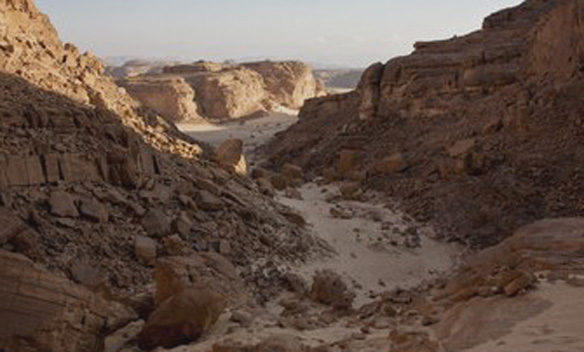
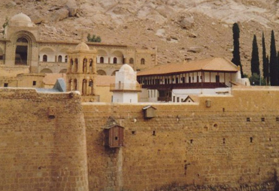
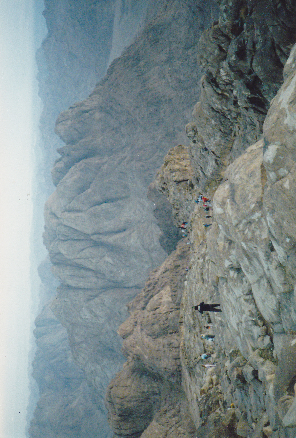
Ich erreichte den Sinai mit dem Bus von Kairo nach Suez, dort nahm ich ein Sammeltaxi, einen alten Peugeot, der von einem örtlichen Beduinen mit großem Stolz gefahren wurde.Der Fahrer hielt von Zeit zu Zeit in der Sinai-Wüste an, wo Beduinen in Zelten wohnten, um ein kleines Gespräch zu führen oder um nur einfach mit der rechten Hand zu winken.Die linke Hand darf aus Gründen, die ich nicht im Detail erläutern möchte, nicht zum Begrüßen oder Essen verwendet werden.Das Einzige, was ich in dieser Hinsicht raten kann, immer Taschentücher aus Papier bei sich zu haben, da das gewohnte Toilettenpapier oft nicht verfügbar war, stattdessem nur eine Flasche Wasser.Das Sammeltaxi brachte mich schließlich völlig sicher ins Zentrum des Sinai und zum griechisch-orthodoxen St. Katharinen-Kloster (siehe nächstes Foto unten).
Das Kloster ist ein ziemlich belebter Ort mitten in der Wüste an der Öffnung einer Schlucht am Fuße des Berges Sinai und ist zudem UNESCO-Weltkulturerbe.Das Gebäude ist eines der ältesten christlichen Klöster der Welt und wurde zwischen 548 und 565 erbaut, es bietet auch die älteste kontinuierlich betriebene Bibliothek der Welt.Der Name stammt aus der antiken Überlieferung, dort erzählt man sich die Geschichte von Katharina von Alexandrien, einer christlichen Märtyrerin, die zum Tode durch Rädern verurteilt wurde, als dies sie nicht töten konnte, wurde sie enthauptet.Die christliche Mythologie besagt, dass Engel ihre sterblichen Überreste später zum Berg Sinai brachten, wo Mönche aus dem nahen Kloster ihre Überreste um das Jahr 800 fanden. Viele christliche Pilger besuchen diesen Ort, und das Kloster bietet ihnen und allen anderen, die hier sein und/oder wie einst Moses auf den Berg klettern möchten, eine Bleibe.
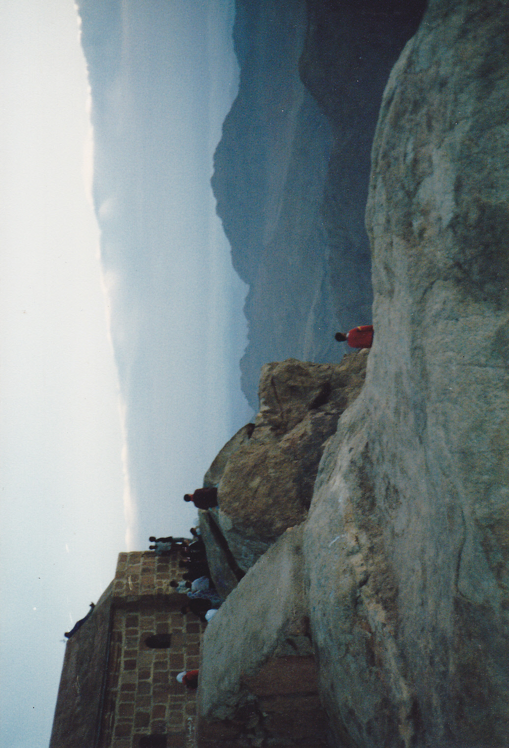
Hier in einer spektakulären Wüstenlandschaft mit all diesen alten Geschichten und Erwartungen zu sein, war schon ein ganz besonderes Erlebnis. Soweit ich mich erinnern kann, verbrachte ich zwei Nächte im Kloster, und an einem sehr frühen Morgen um ca. 4 Uhr, als alles noch völlig dunkel und mysteriös war, begann der Aufstieg zum Berg Sinai zusammen mit ungefähr 40 Personen. Zu dieser Zeit ist es in der Wüste kühl und angenehm, so dass das Marschieren nach oben nur etwa 2,5 Stunden auf einem nicht allzu schwierigen Weg dauerte. Kurz vor Sonnenaufgang erreichten wir die Spitze des Berges Sinai, in diesem Moment waren alle umliegenden anderen Berge in ein surreales Blau und Grün getaucht (siehe Foto oben und unten). Es gab eine große Gruppe von Pilgern aus Österreich, die nach dem Singen eines christlichen Liedes mit großem Pathos die Hymne ihrer Heimatlandes Tirols sangen. Dies machte alles nur noch irrealer, weil im Hintergrund ägyptische Kaufleute laut schrien: “Chai. Hot tea.” Und normalerweise würde man am frühen Morgen nicht so viel Leben inmitten einer Wüste auf alpinen Höhen erwarten.
Oh nein, ich habe nun wirklich keine Erleuchtung auf dem Berge Sinai gefunden, aber die magische Berglandschaft war wirklich einen Besuch wert.Die Wüste ist ein sehr puristischer Ort dabei aber auch höchst riskant, sie kann unserer Geist reinigen oder schlichtweg töten.Viele Europäer sehen die Wüste romantisch, wie es detailreich in Filmen wie ‘Lawrence von Arabien’ gezeigt wird.Jeder Beduine zieht es allerdings vor, in einer Oase mit Wasser und Grün zu bleiben – eine simple Frage des Überlebens.
Die Sinai-Wüste ermöglicht viele Entdeckungen wie Canyons aller Farben, prähistorische Tempel oder den Besuch einer alten Oase.Nach meinem Besuch des Berges Sinai verbrachte ich einige Zeit am Roten Meer, zuerst im ziemlich touristischen Sharm El-Sheikh und danach im eher Hippie-ähnlichen Dahab mit einfachen Strohhütten, die von lokalen Beduinen am Strand vermietet wurden.Dort in Dahab war das Leben damals sehr einfach und entspannt, eine wirklich schöne Erinnerung an dieses besondere und erstaunenswerte Land.
Die Hauptinsel des kanarischen Archipels Teneriffa inmitten des wilden Atlantiks ist ein Ort voller Kontraste, sodass es schwer fällt ein Wort für all das zu finden. Geschaffen durch vulkanische Kräfte vor langer Zeit wird das Zentrum der Insel immer noch durch eine riesige, beeindruckende und archaische Caldera bestimmt, aus der sich der höchste Berg Spaniens, der Teide, erhebt. Auf der Insel finden sich auch verzauberte Schluchten aller Art, alte (Wander)wege, schroffe Küsten und steile Klippen, Sanddünen, Halbwüste, subtropische Zonen, Kiefern- und Lorbeerwälder – perfekte Ausgangspunkte für diverse Erkundungen und spannende Wanderungen in den diversen Klimazonen und Biospheren. Die folgenden Bilder zeigen mehr die expressiven steinigen Aspekte auf dieser so vielfältigen Insel.
Kakteen in der Halbwüste
Schichtungen von Lava
Blick auf den Teide (3718 m) gesehen vom Guajara (2715 m)


 Schichtungen von Lava


You must be logged in to post a comment.